


의 설명 Maverick Pro
Use offline maps and GPS even without an internet connection. This app is great for hiking, boating, geocaching and other outdoor activities.
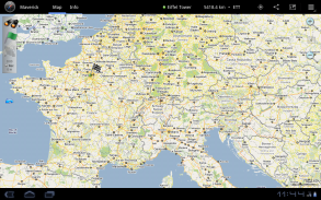
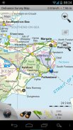
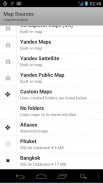
• Multiple global and regional online maps, including: Bing, Yandex, Open Street Maps, OSM Cycle, OSM Public Transport, Multimap, OS Explorer, Ordnance Survey (UK), OutdoorActive (Germany, Austria, South Tyrol), Cykloatlas, HikeBikeMap (Germany), Open Piste Map, NearMap (Australia) and many other maps.
All maps automatically cached for offline use. Use Mobile Atlas Creator to download maps or MAPC2MAPC to convert maps from other formats.
Since version 2.0 you can add custom map servers.
• Share your current or planned position
You can send address, GPS coordinates, link to Google Maps and even map image.
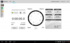
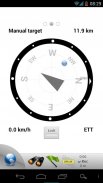
• Navigate easily
Build-in radar shows the direction, distance and estimated time to a point of interest. See all the nearest locations from FourSquare and Footprints.
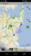
• Find your way back
Trackback function will guide you along a previously recorded track with compass pointing to a nearest point. A new track can be recorded at the same time.
• Challenge yourself
Turn on Trackback and timer to watch your previous position correlated with the current time on track.
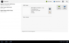
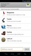
• Save places you visit
All waypoint stored in KML file and can be viewed and edited in Google Earth.
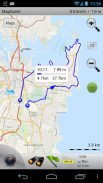
• Record tracks with single tap
Tracks are recorded in GPX format and can be viewed in Google Earth and other software. Share GPX files via email or DropBox.
• Upload tracks to GPSies
Free account is required for uploading.
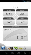
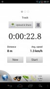
• Trip Computer
Watch speed, altitude, pitch and many other values.
• Support for Honeycomb and Ice Cream Sandwich.
• Ability to use barometer sensor in Galaxy Nexus and other devices.
Only in Pro version:
• Trackback feature
• Unlimited waypoints and tracks
• Multiple files with waypoints
• Lock compass to bearing
• UTM and OSGB grids
• Custom map servers
• FourSquare and Wikipedia support심지어 인터넷에 연결하지 않고도 오프라인지도와 GPS를 사용합니다. 이 앱은 하이킹, 보트, geocaching 및 기타 야외 활동에 좋은 것입니다.
빙, Yandex, 오픈 스트리트지도, OSM주기, OSM 대중 교통 Multimap과, OS 탐색기, 언제나 설문 조사 (영국), OutdoorActive (독일, 오스트리아, 남부 티롤), Cykloatlas, HikeBikeMap (: 포함 • 여러 글로벌 및 지역의 온라인지도, 독일), 오픈 Piste지도 NearMap (호주) 등 여러지도를 제공합니다.
오프라인 사용을 위해 자동으로 캐시 모든지도. 지도 또는 다른 형식의지도를 변환 할 수 MAPC2MAPC을 다운로드 할 모바일 아틀라스 작성기를 사용합니다.
버전 2.0 이후로 맞춤지도 서버를 추가 할 수 있습니다.
• 현재 또는 계획된 위치를 공유
당신은, GPS 좌표, 구글지도, 심지어지도 이미지에 링크를 주소를 보낼 수 있습니다.
• 쉽게 탐색
구축 된 레이더 방향, 거리, 관심 지점에 대한 예상 시간을 보여줍니다. 정사각형과 발자국의 모든 가장 가까운 위치를 참조하십시오.
• 다시 길을 찾기
트랙백 기능은 나침반는 가장 가까운 지점을 가리키는과 이전에 기록 된 트랙을 따라 여러분을 안내 할 것입니다. 새로운 트랙을 동시에 녹음 할 수 있습니다.
• 도전 자신
트랙에 현재 시간과 상관 이전 위치를 볼 트랙백와 타이머를 켜십시오.
• 귀하가 방문하는 장소를 저장
모든 좌표는 KML 파일에 저장하고 조회 및 Google 어스에서 편집 할 수 있습니다.
하나의 탭이있는 • 기록 트랙
트랙 GPX 형식으로 기록되어 있으며 Google 어스와 다른 소프트웨어에서 볼 수 있습니다. 공유 GPX 이메일 또는 보관을 통해 파일이 있습니다.
• GPSies에 트랙을 업로드
무료 계정은 업로드가 필요합니다.
• 여행 컴퓨터
속도, 고도, 피치 및 기타 여러 값을 감상하세요.
허니컴과 아이스크림 샌드위치에 대한 • 지원.
• 갤럭시 넥서스 및 기타 장치에 기압 센서를 사용하는 능력.
만 프로 버전 :
• 트랙백 기능
• 무제한 중간 점 및 트랙
중간 점과 • 여러 파일
베어링에 • 잠금 나침반
• UTM 및 OSGB 격자
• 사용자 지정지도 서버
• 정사각형 및 위키피디아 지원
Maverick Pro - 버전 2.4
(12-12-2013)

Maverick Pro - APK 정보
APK 버전: 2.4패키지: com.codesector.maverick.full동일 카테고리의 앱
좋아할 만한 것...


